Mavic 3 Multispectral

Plant Intelligence for Targeted Action

Effective aerial surveying needs to see the invisible. That’s why Mavic 3 Multispectral has two forms of sight. It combines an RGB camera with a multispectral camera to scan and analyze crop growth with total clarity. Agricultural production management requires precision and data, and Mavic 3M delivers both.


Multispectral Imaging System
Live NDVI View
RTK Module
TimeSync

Mavic 3 MULTISPECTRAL

  • Plant Intelligence for Targeted Action
  • Multispectral Imaging System
  • Live NDVI View
  • RTK Module
  • TimeSync
  • OcuSync
  • D-RTK 2 Mobile Station and NTRIP Compatibility
  • Integrated Spectral Sunlight Sensor

Highly Intergrated imaging system

Multispectral + RGB Imaging System

Newly upgraded imaging system with on 20mp RGB camera and four 5mp multispectral cameras(green, red, red edge, and near-infrared.) Enables applications such as high-precision aerial surveying, crop growth, monitoring, and natural resource surveys.

See Beneath the Surface

Agriculture imagery collection is now simpler and more efficient than ever before with a built-in stabilized imaging system that collects comprehensive data sets right out of the box. Access information collected by 1 RGB camera and a multispectral camera array with 4  cameras covering Green, Red, Red Edge, and Near Infrared bands – all at 2 MP with global shutter, on a 3-axis stabilized gimbal.

Integrated Spectral Sunlight Sensor for Accurate Results

The built-in sunlight sensor captures solar irradiance and records it in an image file, allowing for light compensation of image data during 2D reconstruction. This results in more accurate NDVI results, as well as improved accuracy and consistency of data acquired over time.


Meaningful Data at Your Disposal

Simply having aerial imagery is not enough for ag professionals who want to know more. Switch between a preliminary Normalized Difference Vegetation Index (NDVI) analysis and the live RGB feed to immediately visualize where attention is needed, so targeted treatment decisions can be made quickly.

Centimeter-level Precision

Get real-time, accurate positioning data on images captured by all five cameras with DJI’s TimeSync system, providing centimeter-level accurate measurements. The TimeSync system continually aligns the flight controller, RGB and NB cameras, and RTK module, fixing the positioning data to the center of the CMOS and ensuring each photo uses the most accurate metadata. All cameras go through a rigorous calibration process where radial and tangential lens distortions are measured. The distortion parameters gathered are saved into each image’s metadata, letting post-processing software adjust uniquely for every user.

D-RTK 2 Mobile Station and NTRIP Compatibility

Enhance the accuracy of RTK positioning without internet connection by connecting the Mavic 3 Multispectral to the D-RTK 2 High Precision GNSS Mobile Station and NTRIP (Network Transport of RTCM via Internet Protocol)2, or store the satellite observation data to be used for Post Processed Kinematics (PPK).

The Beginning of Intelligent Agriculture Missions

Plan Flights

Plan flights, execute automated missions, and manage flight data using GS PRO – DJI’s leading flight planning iOS app.

Capture Data

Collect multispectral images efficiently across a large area using the Mavic 3 Multispectral and gain an overview of problem areas.

Analyze Data

Easily access and process aerial data by applying plant-specific metrics and parameters to acquire the desired results on plant health.

Act on Data

Implement targeted treatments on areas that need attention based on accurate drone data.

Precision Agriculture Compatibility

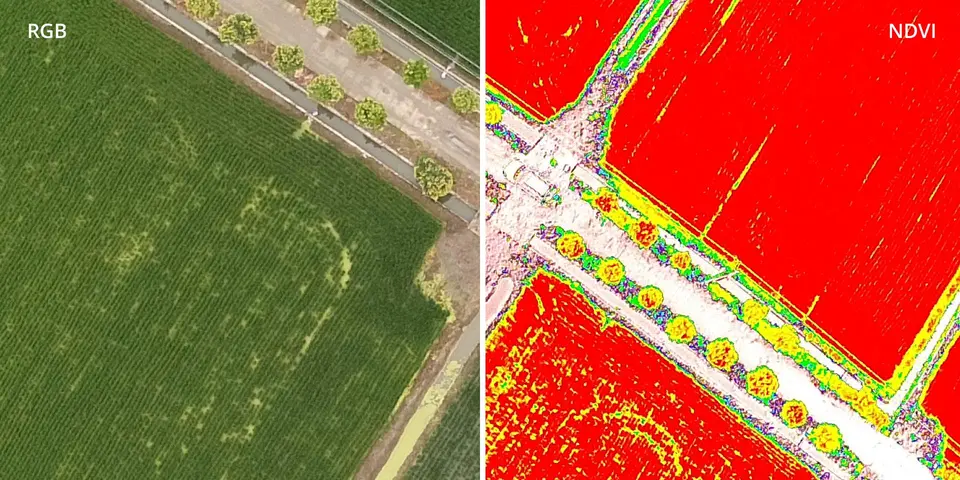
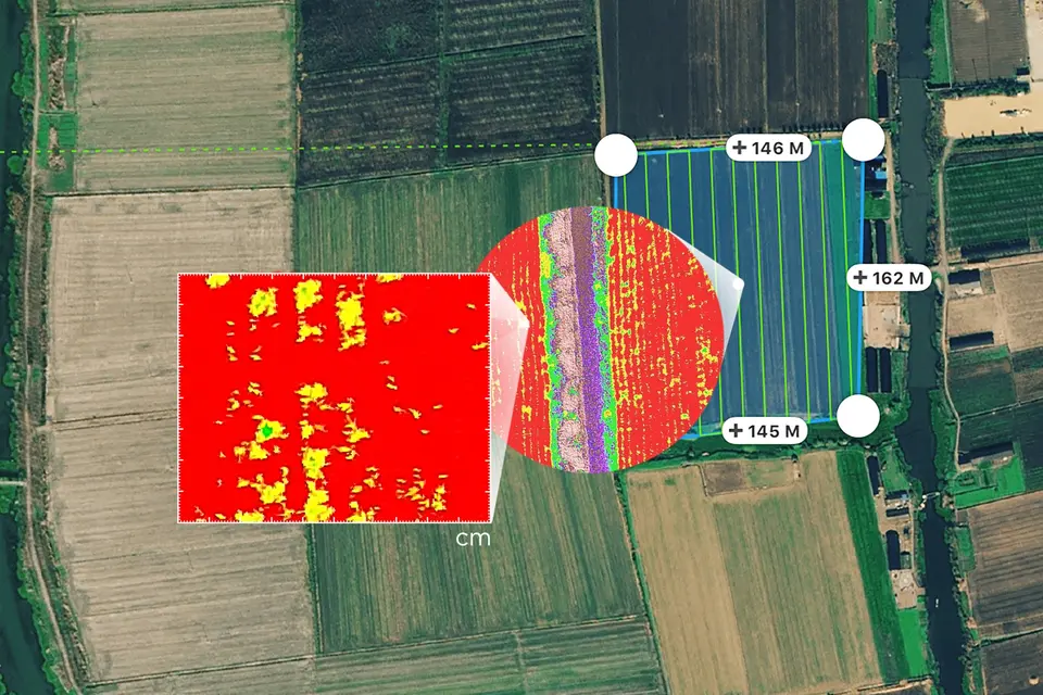
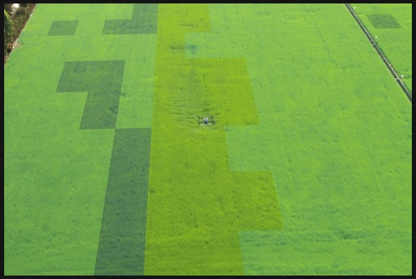
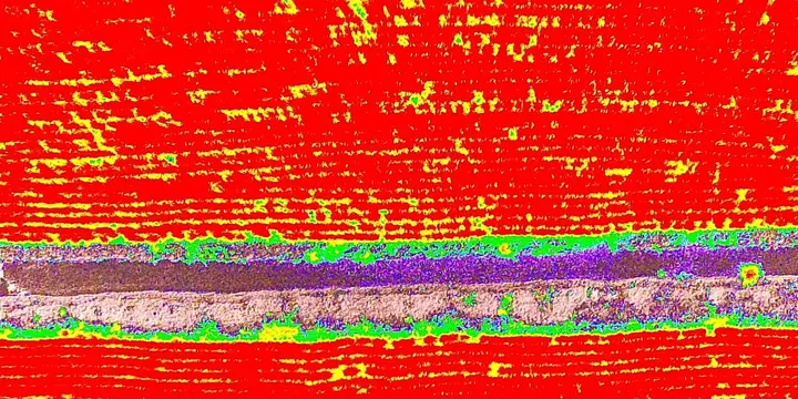
Throughout all growing seasons, multispectral imagery can be helpful to ag professionals by providing information invisible to the human eye across the electromagnetic spectrum. Having access to this data and the subsequently obtained Vegetation Index data such as NDRE and NDVI, farmers can make timely, informed decisions on crop treatment, lowering costs, saving resources, and maximizing yields.

Environmental Monitoring and Inspection

Routine inspections and maintenance involving plants can be made smarter and more efficient when using the M3 Multispectral – leverage its actionable multispectral insights to monitor forest health, measure biomass, map shorelines, or manage riparian vegetation while protecting habitats or ecosystems, and much more.